SWITZERLAND
MATTERHORN
|
ALL ABOUT SWITZERLAND |
|
ZERMATT MATTERHORN |
|||||
Swiss Cities Basel Bern Geneva Lausanne Lucerne St. Gallen Winterthur Zurich Alpine Resorts Bernese Oberland Zermatt / Matterhorn · Matterhorn · Gornergrat · Zermatt · Randa · Täsch · Findeln · Festivals · Museums · Sports · Webcams Swiss Tour Chillon Castle Rhine Falls |
Zermatt - Matterhorn - Gornergrat
|
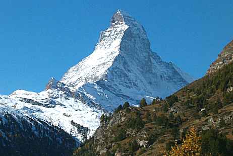
Majestic mount Matterhorn / Monte Cervino (4478 m / 14,692 ft) is not Switzerland's hightest, but certainly its best known alpine peak. Its popularity is enormous among mountaineers and would-be-mountaineers from all over the world. Some 3000 people per year try to climb it - but not all are fit enough to reach the summit. Matterhorn remains a real challenge, demands quite some mountaineering experience and taking a professional guide is a must for anybody who is not absolutely familiar with the routes, local weather conditions and procedures in case of emergency. Probably the fact that Matterhorn is not the most difficult but rather the most popular alpine summit results in several persons losing their lives while attempting to climb it each year.
 |
Zermatt mountain guide's office: Alpincenter |
Since Edward Whimper and his team first climbed Matterhorn summit on July 14th, 1865, the Hörnligrat [Hörnli ridge] route has remained the classical one. Following common mountaineering practice in the alps, the ascent takes two days: on day one, people ride to Schwarzsee in a cable car and hike up to Hörnlihütte (3260 m / 10,695 ft). Despite its name, Hörnli hut is not a cottage but a rather large stone building. Spending the night up in this "base camp" is a must and serves two purposes: First it helps to accomodate to thin air and second teams may start the main part of the ascent as early as 4 a.m. to get up to the summit and back before the ice and snow surfaces begin to melt in the sun, getting dangerously slippery and before there is an increased risk of afternoon clouds and thunderstorms. Parties in danger may seek refuge in Solvayhütte, situated in the middle of the route at 4003 m [13,133 ft].
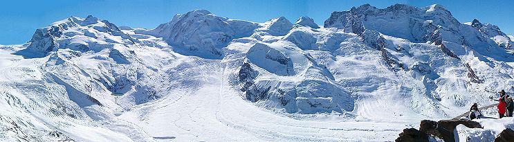
Part of the panoramic view as seen from Gornergrat including glacier and Dufourspitze,
Switzerland's highest mountain (4634 m / 15,203 ft)
Gornergrat is a first class view point on a ridge offering an awesome alpine panorama.
29 mountain peaks above 4000 m [13,100 ft] can be seen from Gornergrat, among them
the Monte Rosa massif with Dufourspitze, Switzerland's highest peak.
Dufourspitze has been named after Geneva born Swiss General
Guillaume Henri Dufour who has great merits for the introduction
of a common Swiss flag and for ending Switzerland's 1847 civil war within a few days
after conservative rebels had started it. With his clear strategy he showed them that
they had no chance to win right from the start and he insisted that his soldiers
did not commit atrocities (which was quite unusual at the time).
Dufour was also the first to draw modern geographical maps and finally he was
a friend of Henri Dunant and co-founder
of the International Committee of the Red Cross (ICRC).
Gornergrat can be reached in a 40 minutes ride with Gornergratbahn. When it was built in 1898 this cogwheel railroad was the first in Switzerland to be operated electrically. As a particularity it shares with Jungfraubahn, three phase current is used. Therefore these trains have two catenary wires (plus the rails) to feed them with power. Be prepared that fares reflect the challenges of operating and maintaining a steep track leading from 1600 m to 3131 m [10,272 ft] under extreme weather conditions.
In summer you may reach Gornergrat on foot, too. There are several scenic hiking paths. You will need good shoes, but no special mountaineering equipment. The altitude difference between the village and Gornergrat is considerable, though.
Gornergrat satellite view: www.search.ch
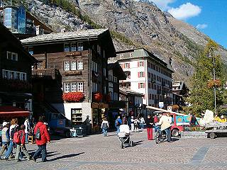 |
Zermatt is a prime destination for those loving awesome mountain scenery, mountaineering, skiing and snowboarding - and one of the few alpine resorts that can offer skiing even in summer. There are several high classed hotels and restaurants in Zermatt, but this does not really affect the charming rural character of the town. |
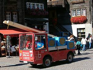
A few alpine resorts in Switzerland, among them Zermatt, Saas Fee and Bettmeralp/Riederalp in canton Wallis, are kept free of cars and trucks. Small vehicles driven by electric motors are used to distribute heavy loads and there are even some electric taxis. Access to Zermatt is by railroad only. Visitors must park their cars in Täsch or further down in the valley. If you like the calm atmosphere created by the absence of cars, Zermatt is a good choice. If individual mobility is very important for you even during holidays, however, alternatives like Davos, Engelberg, Grindelwald, Klosters and St. Moritz will serve you better. |
 |
Zermatt Map: www.search.ch
Randa is a nice little village situated 15 minutes below Zermatt on 1400 m [4600 ft] above sea level. There is one hotel, but the focus lies on other types of accommodation: a number of apartments (small flats) are on rental on a weekly basis for those willing to do some cooking. Randa has a camping facility, and some backpacker hotels with reduced service standards, too. Randa may be a real alternative to Zermatt for young tourists on budget willing to share a room with several other persons.
Four cottages run by the Swiss Alpice Club (SAC) on 2200 to 2900 m [7200 to 9500 ft] are starting points for mountain hikes. These cottages may be reached on hiking paths only, however. Mountaineers might use them as a base camp to climb several nearby peaks within a few days without returning to the valley. Warm meals are served in these cottages, but otherwise accomodation in cottages is rather spartanic.
Randa Map: www.search.ch
Täsch is an autonomous village half way between Randa and Zermatt on 1449 m [4754 ft] above sea level with a population of slighly over 1000. Täsch is the terminal point for those who want to reach the Zermatt region by car.
Täsch Map: www.search.ch
Findeln is the smallest hamlet belonging to Zermatt, situated in a side valley in parallel to Gornergrat.
Like elsewhere in Switzerland, small and rural does not necessarily mean 'out in the middle of nowhere'. Distances are small and if there is potential to attract people from a nearby city or major tourist resort, Swiss top-class cooks tend to establish themselves in the countryside. So you might want to explore some restaurants in Findeln.
Findeln Map: www.search.ch
In summer hiking, mountain biking, mountaineering, climbing and paragliding dominate the scene from June to September. There is no guarantee for favourable weather in any season, however. Weather conditions tend to change from day to day in the Alps and periods of warm and dry weather lasting for several weeks are rather the exception than the rule.
Skiing and tobogganing are the main winter attractions, the prime seasons lasts until end of April. Zermatt is among a handful of resorts that can offer skiing even in summer, however. Thanks to glaciers and eternal snow 18 km [11 miles] of ski runs are open all year.
Links to webcams provided by different operators from the Zermatt / Matterhorn / Gornergrat region
| Zermatt town and villages | Matterhorn & glacier views | Ski resorts |
|---|---|---|
|
|
|
| Best local time to see European live webcams: | ||
| America: morning | India: afternoon | East Asia / Australia: evening |
|
Zermatt Tourist Office |
|
Randa Tourist Office |
|
Mountain guide's office: Alpincenter |
| Zermatt resort overview / map: google |

Short quotations allowed but with precise declaration of origin (Link).
Reproduction of substantial parts and pictures in printed or electronic form
only with explicit written consent by the editor.
| Disclaimer | Privacy Policy | www.all-about-switzerland.info © 2005-2010 All Rights Reserved | Editor | ||